
The Prime Minister has just approved Nha Trang City master planning adjustment till 2025 with many important contents...
The Prime Minister has just approved
Nha Trang City master planning
adjustment till 2025 with many important contents.
Building bridge connecting Tran Phu St. with Nguyen Tat Thanh Ave.
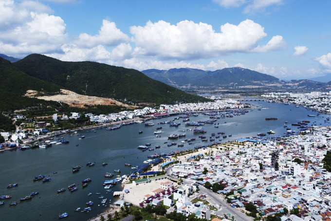
3 areas in Nha Trang City subject to the adjustment include Nha Trang Port and its vicinity (Vinh Nguyen Ward and Vinh Truong Ward); Hon Tre - Hon Mot Islands (Vinh Nguyen Ward); Hon Thi area (Phuoc Dong Commune). The total area under local planning adjustment is about 1,276.56ha, accounting for 4.5% of the natural area under to Nha Trang City master plan till 2025 approved by the Prime Minister in 2012. Accordingly, the land functions are converted from hills (1,162 ha), unused land (14.75 ha), water surface (24.9ha), land for tourism and services (64.3ha), land for traffic and key works (10.25ha) to urban tourism land.
|
The Government has decided to add 44.4ha to the urban service land of Nha Trang Port and its vicinity. The land is converted from 19.4ha of water surface, 14.75ha of unused land and 10.25ha of traffic land and focal works in the approved 2012 master plan. Particularly, the Prime Minister has given approval to go ahead with the construction of a new Hon Ro Bridge running through Quan Truong river estuary. This bridge is designed to connect Tran Phu Street with Nguyen Tat Thanh Avenue, forming a coastal connection road running from Cam Ranh International Airport to Nha Trang City. The construction density criteria in the area remains at a maximum of 40% and 40 storeys.
Maximum construction height of 20 storeys on Hon Tre Island
The Prime Minister’s decision also stated that 1,165 hectares of land for urban tourism will be supplemented to Hon Tre island. This area is converted from 5.5ha of water surface, 1,123ha of unused hilly land and about 46ha of tourism service land in the approved planning in 2012. 37.24ha of unused hilly land and tourism service land in approved planning in 2012urban tourism will be supplemented to Hon Mot Island.
The average construction height is 5 storeys on Hon Tre Island and 3 storeys on Hon Mot Island. Particularly at 8 clusters of Hon Tre Island tourist centers, the maximum construction height is 20 storeys. The construction height limit on Hon Mot Island is 5 storeys, applied for some main hotels. However, the construction site, size and architecture on the 2 islands are based on subdivision planning, detailed planning and urban design decided by the Provincial People's Committee.
In addition, 30ha subject to partial adjustment on Hon Thi is converted from hilly land, which is under planning approved in 2021. 9ha of residential land, 3ha of public service land, 6ha of traffic land and other connection works; 11ha land of trees and land for other use purposes. The population is expected to be some 2,000 with the construction density of 35% and the maximum height of 15 storeys.
Nha Trang City is collecting ideas and suggestions from communities on the zoning of Hon Tre Island - Hon Mot Island, 1/2000 scale; and Nha Trang Port and its vicinity, scale 1/2000. The planning will make the most of the topographical features and natural conditions, promoting the appearance and urban landscape of sea and island tourism, creating a highlight for Nha Trang Bay; turning an island complex into a modern and luxurious urban tourism center on the basis of harmony with the natural environment and topography. The tourist port is planned to meet international standards with technical infrastructures synchronized with the existing communities, according to the report of Nha Trang City People's Committee.
Within the local adjustment scope, land for residence combined with commerce, service and tourism accounts for 36%; urban public service land: 1%; land for traffic and key works: 15%; land for trees and for other use purposes outside the residential area: 48%. The population in the areas under planning adjustment is forecast to be about 7,000, up by 2,000 people compared with 2019, accounting for 0.43% of the urban population forecast by 2025.
V.K
Translated by N.T


